

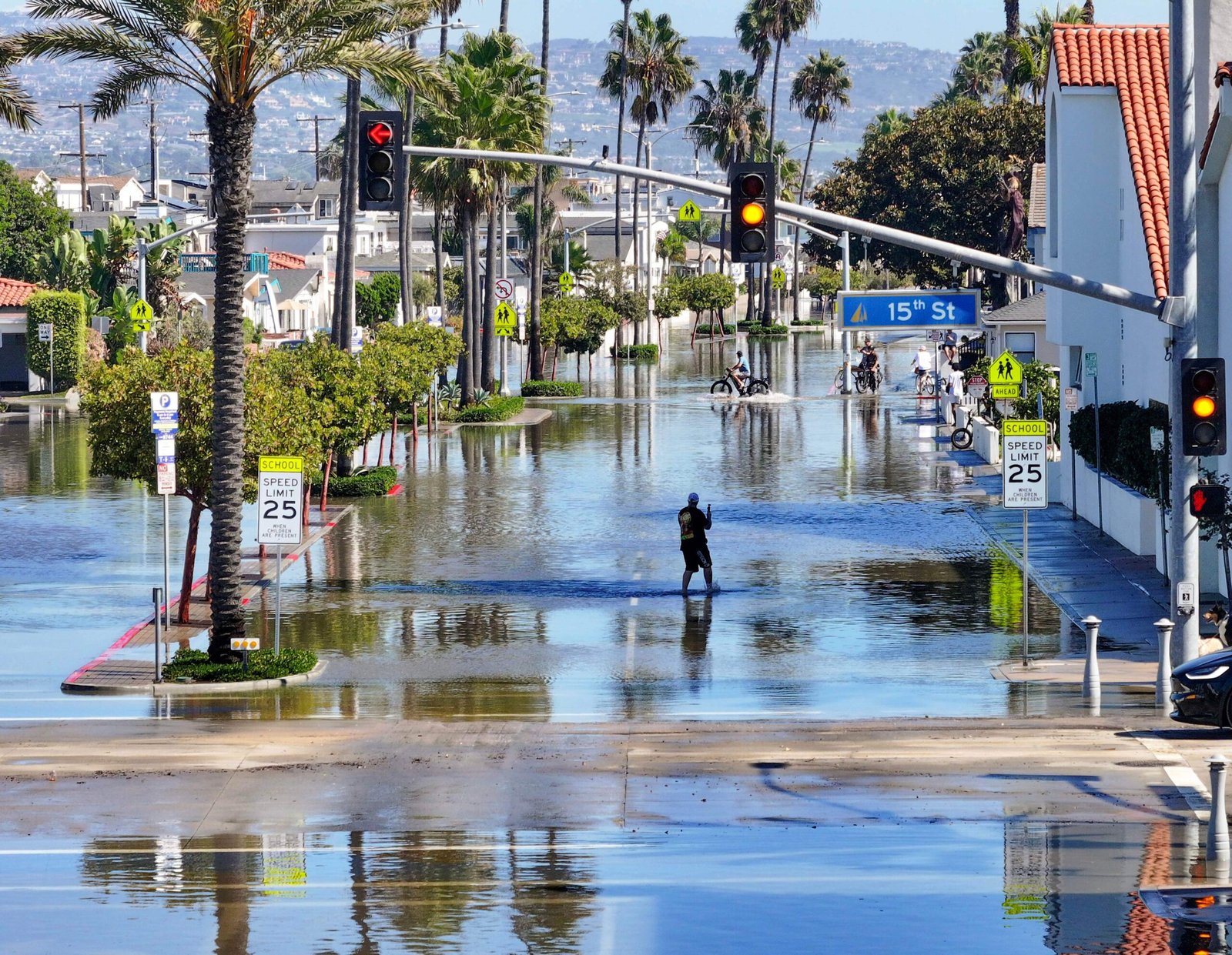
Newport Beach closed all city beaches and piers Saturday morning, Oct. 10, as crews worked to alle Southern California, threatening heavy rain, strong winds and even more of a mess on Sunday
The closures came a day after powerful swells and unusually high tides sent seawater spilling onto streets in Newport Beach and Laguna Beach, forcing road closures and prompting crews to pump water from neighborhoods.
In Long Beach, punishing waves battered the Peninsula on Friday, damaging a protective bulkhead, flooding nearby homes and streets and prompting evacuations, with some homes red tagged after being swamped by unusually high tides.
It’s bad. It’s going to be a lot
“It’s bad. It’s going to be a lot of things to fix when this is over,” said Long Beach Peninsula resident Brian Gerrard on Saturday. “It’s a once-in-a-lifetime storm. Who’s prepared for that?”
And the worst may be ahead.
The National Weather Service has issued coastal flood warnings for Orange County and Los Angeles County beaches, including Long Beach and Malibu, through 3 p.m. Sunday, warning that damaging floods and beach erosion are likely.
The morning high tide occurred around 9:15 a.m. Saturday in Newport Beach and 9:25 a.m. in Long Beach. On Sunday, the high tide is forecast around 9:40 a.m. in Newport Beach and 9:50 a.m. in Long Beach, when powerful surf could again send seawater into vulnerable coastal communities.
High tides are expected to reach between 7.3
High tides are expected to reach between 7.3 and 7.5 feet along the Los Angeles County coast this weekend.
The weather service warned that Sunday could bring even higher water levels if lower atmospheric pressure associated with Rachel and stronger onshore winds coincide with the morning high tide.
Meanwhile, Rachel’s moisture is expected to combine with another weather system, bringing widespread rain to Southern California beginning late Saturday.
As of 8 a.m., Rachel had maximum sustained
As of 8 a.m., Rachel had maximum sustained winds of 60 mph and was moving northeast at 22 mph, according to the National Hurricane Center.
The storm’s precise track remained uncertain, but forecasters said its center was most likely to move into northern Baja California, south of the U.S.-Mexico border.
A less likely track farther north could increase rainfall and wind impacts in Southern California.
The National Weather Service forecast rainfall totals ranging
The National Weather Service forecast rainfall totals ranging from about three-tenths to half an inch in northwestern Orange County to three-quarters of an inch to 2 inches in parts of the Inland Empire.
Mountain areas of the Inland Empire could receive 2 to 3 inches, with higher amounts possible in some spots, said Casey Oswant, a meteorologist with the NWS.
The heaviest rainfall could produce flash flooding, particularly in mountainous areas and near wildfire burn scars.
A flood watch was issued for the San
A flood watch was issued for the San Bernardino and Riverside county mountains and several desert areas from Saturday evening through Sunday evening.
Mountain communities including Wrightwood and Oak Glen could face flooding concerns because of steep terrain and nearby wildfire burn scars.
Forecasters warned that rainfall rates in some mountain areas could reach half an inch to an inch per hour, potentially triggering flash flooding and debris flows.
Gusty winds are also expected Sunday, with gusts
Gusty winds are also expected Sunday, with gusts of 25 to 45 mph possible across coastal and inland areas and stronger gusts near mountain ridges.
Los Angeles County is expected to see lighter rainfall than areas farther south, although an approaching low-pressure system will help draw tropical moisture into the region.
In Long Beach on Saturday morning, a city crew remained at 63rd Place and Ocean Boulevard, pumping water from the ocean that was traveling toward Ocean Boulevard back out toward Alamitos Bay as nearby residents milled about, observing the scene and taking photos or videos on their phones. One man wheeled a cart full of sandbags, presumably back to his home.
Jim Gesner, a 16-year resident of the Peninsula
Jim Gesner, a 16-year resident of the Peninsula community, said his home on 67th Place hasn’t been directly impacted by the flooding, but he spent the last couple days moving some items from the first floor to higher ground as a precaution.
He recalled some flooding about 11 years ago but said it was nothing like what the city is facing this weekend.
“I feel really bad for my neighbors who have property on the beach. They’re losing their houses,” he said, adding that many residents don’t bother purchasing flood insurance because it’s so expensive.
Gesner said it was reassuring to see more
At the same time, Gesner said it was reassuring to see more city workers out Saturday morning, helping pump out the ocean water to keep the street from flooding. Ocean Boulevard was flooded from about 62nd to 65th Place on Friday morning before City workers cleared much of the water out by about noon, he said.
“I think they’re doing what they can at the moment,” he said.
The National Weather Service predicted a quarter-inch to an inch of rain through Monday, with locally higher amounts possible in the mountains, particularly the eastern San Gabriel Mountains.
Another round of rain is possible Monday, along with a slight chance of thunderstorms.
Temperatures will also remain considerably cooler than during Southern California’s prolonged October heat wave, with highs generally in the 60s and low 70s by Monday.
Along the coast, forecasters warned that the combination
Along the coast, forecasters warned that the combination of high tides, incoming swells and onshore winds could create particularly dangerous conditions Sunday.
A high surf advisory is in effect for Los Angeles County beaches from 6 a.m. to 10 p.m. Sunday, with waves of 4 to 7 feet expected, along with strong rip currents and significant beach erosion.
Large breaking waves could sweep people off beaches and rocks or capsize small boats near shore, the National Weather Service warned.
Orange County beaches could see surf of 5
Orange County beaches could see surf of 5 to 7 feet, with local sets reaching 9 feet Sunday. On Saturday morning, the Crystal Cove Conservancy announced it would temporarily close some of its popular beachfront vacation cottages.
In Newport Beach, city crews spent Friday into Saturday pumping seawater from flooded streets and reinforcing sand berms to protect vulnerable neighborhoods.
The flooding came just days before a Newport Beach City Council study session scheduled for 4 p.m. Tuesday, Oct. 13, to discuss severe beach erosion, sand replenishment and possible long-term shoreline protection strategies.
Councilmember Erik Weigand visited the Balboa Peninsula
Councilmember Erik Weigand visited the Balboa Peninsula on Friday with Brett Sanders, a professor of civil and environmental engineering and director of UC Irvine’s Climate Collaboration, to survey the flooding.
“I don’t see this ending,” Weigand said. “Maybe this El Nino comes and goes, but what about the next El Nino. What does it mean for our residence, tourism and our businesses?”
The flooding concerns could persist well beyond this weekend.
Sanders said tides are expected to reach about 7 feet around Thanksgiving and Christmas. If Kelvin waves — ocean disturbances that can temporarily raise sea levels — persist, water levels could rise as much as 2 feet above normal, potentially producing 9-foot tides.
“Pray there aren’t waves at the same time,” Sanders said. “If the waves come at the same time, we’re in for a lot of trouble.”
City News Service contributed to this report.
