

Governor Newsom announces completion of major Sacramento Valley flood project ahead of El Niño
As Trump undermines flood preparedness, Governor Newsom strengthens California’s flood defenses to help protect homes, businesses, and communities
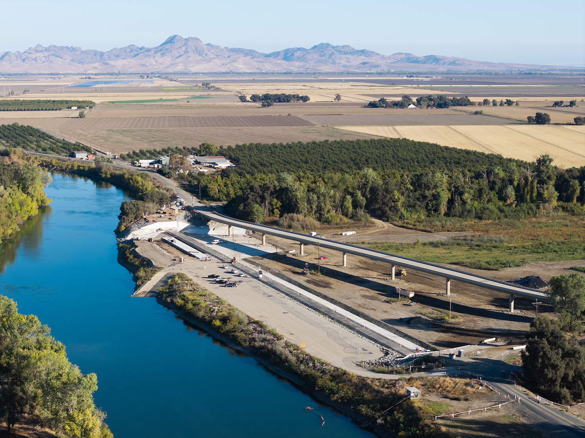
Tisdale Weir in Sutter County strengthens flood protection and improves fish passage along the Sacramento River.
What you need to know: California has completed the Tisdale Weir Rehabilitation and Fish Passage Project, a major upgrade to a critical flood-control structure that helps protect Sacramento Valley communities ahead of potential El Niño storms. Under Governor Newsom’s leadership, the state is strengthening flood defenses, positioning emergency supplies, and preparing for flooding before severe weather strikes.
SACRAMENTO – Governor Gavin Newsom today announced the completion of the Tisdale Weir Rehabilitation and Fish Passage Project, strengthening a critical structure that moves high water away from communities and reduces pressure on downstream levees ahead of potential El Niño storms.
The Department of Water Reweir, which diverts high flows from the Sacramento River into the bypass system
When the river rises, families need to know the infrastructure protecting their homes will do its job. While Donald Trump undermines disaster preparedness, California is strengthening the flood defenses that help keep water out of homes, businesses open, and communities safe.
California’s work comes as the Trump administration has canceled or stalled investments that help communities prepare for flooding and other disasters, prompting legal challenges and court orders to restore disaster-prevention funding.
“This project is a win-win for people and nature,” said California Secretary for Natural Reflooding by enabling water to overtop into the bypass when the Sacramento River is high. It also provides fish that come into the bypass safe passage back to the Sacramento River, which advances our Healthy Rivers and Landscapes program. The project will make a difference this winter as storms intensify across our state.”
Strengthening a critical line of defense
Originally constructed in 1932 by the U.S. Army Corps of Engineers, Tisdale Weir is a state-owned component of the Sacramento River Flood Control Project and one of five major weirs on the river.
“California’s flood protection system depends on infrastructure that has served our communities for generations, and we must continue investing to keep it reliable,” said DWR Director Tom Gibson.“The Tisdale Weir project is a great example of how we’re modernizing that infrastructure to meet today’s challenges, reducing flood risk for Sacramento Valley communities while improving conditions for fish in the Sacramento River.”
When storms cause the Sacramento River to rise, the weir is one of the first structures to help relieve pressure on the flood-control system. During high-water events, it can divert up to half the river’s flow through the Tisdale Bypass into the Sutter Bypass, helping protect downstream communities. That function is especially important when successive storms keep river levels elevated for extended periods, putting additional stress on levees. The rehabilitation helps ensure the historic structure can continue performing its essential flood-protection role.
The project also includes significant improvements to fish passage, particularly for Chinook salmon and green sturgeon. Historically, fish migrating through the Tisdale Bypass could become stranded behind the weir when Sacramento River levels dropped. The new fish passage includes a gated opening in the weir, a connecting channel to the Sacramento River, and a redesigned basin that helps guide fish back to the river as floodwaters recede. These improvements reduce the risk of fish stranding while preserving the weir’s critical flood-control function.
Preparing California before storms arrive
Governor Newsom has taken a series of early and decisive actions to prepare California for El Niño impacts, bringing together state agencies and local partners to strengthen flood defenses, equip emergency responders, and protect critical infrastructure.
In September, the Governor proclaimed a state of emergency to bolster statewide El Niño preparedness, directing agencies to protect vulnerable communities, prepare roads and infrastructure, stage emergency supplies, and help address flood, landslide, and coastal risks.
The Governor also signed an executive order targeting threats to Highway 1 and coastal communities, establishing a Highway 1 Task Force to assess risks and develop a plan to address them ahead of El Niño impacts.
In a separate executive order, the Governor streamlined storm preparedness projects, including repairs to levees, clearing debris from waterways, and protecting vulnerable infrastructure.
The Department of Water Re is working with local communities and the Governor’s Office of Emergency Services (Cal OES) to prepare for potential flooding
Additional preparations include:
- Staging life-saving supplies:DWR has stockpiled flood-fighting materials at 68 locations statewide. These materials include 4.4 million sandbags, over 52,000 feet of “Muscle Wall” — portable flood barriers that crews can quickly deploy to divert water — and 400,000 tons of rock for emergency levee repairs.
- Inspecting and maintaining infrastructure:Crews are also moving swiftly to inspect and prepare California’s flood-control infrastructure. Each fall, the state inspects all 1,600 miles of levees under the State Plan of Flood Control and maintains other weirs, bypasses, and flood control structures across the state. The system includes major flood-control infrastructure in the Sacramento and San Joaquin valleys, extending north to the Oregon border.
- Coordinating with local partners:DWR is working with counties, cities, and other government agencies across California through more than a dozen regional preparedness workshops statewide, with technical assistance, engineering guidance, and emergency response to local partners responsible for levees. Through the Dam Safety Planning Unit, Cal OES reviews and approves dam emergency action plans and supports coordination to protect downstream communities during a dam emergency.
- Preparing dams for potential heavy rain:DWR has notified dam owners statewide to prepare for potential El Niño-related storms. Its Division of Safety of Dams inspects all high- and extremely high-hazard dams annually and evaluates older dams for seismic and flood risks.
- Keeping the State Water Project ready: The system supplies water to 27 million Californians and has performed annual maintenance and inspections to prepare for winter operations.
Trump’s retreat from flood protection
Since taking office in 2025, the Trump administration has cut or sought to cut investments that help communities prepare for floods and other disasters:
- Zeroed out funding for four California flood projects:The Trump administration’s fiscal year 2025 Army Corps of Engineers work plan provided no construction funding for four California flood-control projects that had been slated to receive a combined $126.4 million under the previous administration’s budget request and both House and Senate draft funding bills. The projects included American River Common Features, Natomas Basin; Pajaro River at Watsonville; Lower San Joaquin River; and West Sacramento.
- Proposed slashing Army Corps construction funding:The President’s fiscal year 2026 budget proposed $1.56 billion for Army Corps construction, 53% below the fiscal year 2024 enacted level, and omitted funding for those same four California flood-protection projects.
- Tried to eliminate disaster-prevention grants:The administration canceled FEMA’s Building Resilient Infrastructure and Communities program, which helps communities reduce flood and other disaster risks before emergencies strike. California and 19 other states sued to challenge the cancellation, and courts ordered the program restored. Despite its reinstatement, CBS News reported November 5 that California projects continued to face funding delays.
What is El Niño?
El Niño refers to the periodic warming of sea surface temperatures in the eastern Pacific Ocean. Usually, the tropical western Pacific is warmer than the tropical eastern Pacific. In El Niño, that pattern reverses, and the eastern Pacific warms significantly. This changes circulation and precipitation patterns around the world.
Specific local impacts are unpredictable, but El Niño often brings more frequent and intense storms over California. These storms can produce dangerous flooding, landslides, debris flows, erosion, and other dangerous impacts.
How Californians can prepare
El Niño does not guarantee a wet winter or any particular storm, but it heightens the risk of strong storms in California. Californians should prepare now for the possibility of heavy rain, snow, and flooding:
- Sign up for alerts.Get local emergency alerts here and follow trusted sources.
- Know your flood risk.Find out whether your home or workplace is in a flood-prone area or downslope of an area recently affected by wildfire, where heavy rain can increase the risk of flooding, debris flows, and mudslides.
- Stay informed. Pay attention to weather forecasts and sign up for emergency alerts from your city or county. Conditions can change quickly during major storms, so follow instructions from local emergency officials.
- Have an evacuation plan.Know where you would go and how you would get there if you need to leave quickly. Keep an emergency kit ready, including plans, medications, and supplies for pets and other animals.
- Never drive through floodwater.Water on flooded roads can be deeper and faster-moving than it appears, and roadways may be damaged or washed out beneath the water. Turn around and find another route.
For flood-risk tips by region, a household checklist, and what to do after a storm, see Cal OES’s Listos California El Niño preparedness guide.
